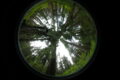
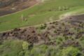
Situated in the Alpine tundra in the hills above Boulder, Colorado, Niwot Ridge’s Tundra Lab is among the highest research laboratories in the continental United States. The lab is a squat, hardened, concrete structure perched on stilts on the side of a mountain, more military bunker than college building. Yet the concrete semi-circle is just a gateway, a stopping point to towering peaks, six permanent glaciers and a sprawling valley of lakes that comprise the Niwot Ridge LTER. When I visit in April, the landscape is a patchwork of glaring white snow with gold-flecked tundra peeking through.

Snow is the defining control on Niwot’s ecology. Through the winter, the white stuff builds with each passing storm; sometime in the spring, melting begins, flushing water and nutrients through the system.
When winter conditions are present, much of the ecology activity in the ecosystem slows or halts completely: plants lie dormant under the snowpack, lakes freeze over and the critters within them slow down until spring. But snow is also integral to the survival of a diverse range of creatures in the alpine. Tiny microbes and warm blooded pika, for example, both benefit from snow’s insulating protection from harsh temperatures through the winter. “One exciting thing with winter ecology research is just how much activity goes on during winter,” says Jen Morse, Niwot’s lead climate, water, and snow technician.
The snow has a dramatic physical influence on the environment, too. Suspended for months above frozen tundra is a huge quantity of water and nutrients deposited on the snowpack; when and how fast the snowpack melts determines the timing and magnitude of a critical suite of downstream processes.

The snow survey
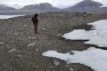
Each spring, researchers and volunteers trek to the Tundra Lab to manually survey snow depth across the entire Upper Green Lakes Valley watershed. The annual snow survey is a pillar of Niwot Ridge’s science. This year, they invited me to tag along.
I ride up to the Tundra Lab with Jen behind the joysticks of a bright red snowcat. It’s a remarkably slow and bumpy journey until we hit the snow line, where the treads of the snowcat can finally sink in. The rest of the group, composed of graduate students, technicians, and volunteers, hike and then cross country ski up the same trail. We carry their supplies.
When I meet Jen, she’s shoving sandwich fixings into a tote, buzzing with energy and excitement. She’s been planning the survey for months. For Jen, this marks the end of a long winter of traveling to the station with just one or two others. Summer is around the corner, and the Tundra Lab will finally be buzzing with people again.
The snow survey is a three-day ordeal, involving over a dozen people armed with skis, depth probes, and GPS trackers. The group stays at the Tundra Lab, sleeping well above eleven-thousand feet, and aims to sample five hundred points across the watershed.
Hitting five hundred sampling points is critical: that volume of data gives enough statistical power to their snowpack models that researchers can sample randomly across the watershed instead of needing to find the same points year to year.

In an era of high tech remote sensing and sophisticated sensors, manual sampling is valuable for two reasons. First, manual sampling provides a way to ground truth new technology and bridge the gap between old and new methods. Second, manual sampling is essential for continuity of the Niwot snow dataset and the long-standing snowpack models developed using the dataset. A long-term dataset collected with the same technique for its lifespan ensures that any changes detected are a result of a change in environmental conditions, rather than research methods.
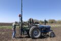
On the ride up to the alpine, we pause to look at an instrument in a small, elevated box. If there is any evidence of the value of maintaining consistent sampling methods over time, it’s this. Inside the box, a stylus charts a line on a roll of green graph paper, adding yet another minute’s worth of data to the longest continuous high-altitude precipitation record in North America. Adjacent lies a device recording CO2 concentration, adding data to the third longest atmospheric carbon dioxide dataset on the planet. Both instruments are now decades old and dinosaurs compared to newer sensors. Yet the value of consistent methodology far outweighs the convenience of modern tech. In fact, the data are considered so valuable that when all other research activity at Niwot halted from the COVID-19 pandemic, researchers still hiked up to the instruments each week to change out the graph paper containing temperature data and collect the canisters of air holding CO2 measurements.
Stick and poke
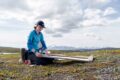
The snow survey is an important reminder, in an era of complicated computer algorithms, simulated ecosystems, and big data, that good science can be dead simple. On the snow survey, researchers measure snow depth with a thirty foot aluminum stick: think a reinforced tent pole. They take a GPS reading, mark the depth and move on. Sometimes, there is no snow: the pole hits the tundra, the volunteer marks the depth as zero.
Snow depth provides the sheer volume of snow across the landscape. But of equal importance is the amount of water contained in the snow. A snowpack is never homogenous. It’s highly layered, with some bands dense and wet and congealed, others light and dry. The bands are a record of both snowfall and the ensuing environmental conditions. A big storm followed by a long, cold, and dry period will cause the snow to form into angular, cupped crystals called facets, which are then buried with the next storm. During a consistent, warmer snowfall, however, flakes bond together, creating a denser and more stable snowpack.
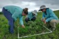
Snow pits, dug down to ground level, let researchers observe how the snowpack changes through its depth. Several are dug each survey, and researchers use the density of each layer to measure the snow water equivalent—the actual amount of water contained in a given volume of snow—of each layer.

Such a precise record of historical snowpack is immensely useful. At its simplest, the snow survey provides Boulder, Colorado an estimate of their water supply; the Green Lakes Valley watershed, where the Niwot Ridge LTER resides, funnels water straight to the city.
A record of change
Over time, and when coupled with additional experiments, the snow survey record reveals how the alpine ecosystem changes as the climate changes. For example, researchers at Niwot sprinkle an experimental plot with black sand each year to encourage rapid melt. They compare the flora and fauna in the sand covered plots to control plots that are left to melt undisturbed.The results simulate a warmer spring. In plots dusted with sand, plants “green up” earlier and grow for longer—but also stop growing earlier in the fall than plants where the snow was undisturbed.
Similarly, human activity in the nearby Front Range has increased atmospheric deposition of nitrogen and phosphorus at Niwot Ridge and across the Rockies. During winter, these deposited nutrients get trapped in the snowpack, but are flushed out when spring melt begins. The timing of both deposition, snowfall, and ultimately, snowmelt all determine when and how intensely these nutrients reach the tundra below the snow, but also the downstream areas in the watershed. And while the snow survey determines the magnitude of these fertilization effects each year, researchers at Niwot also artificially fertilize plots across the watershed to see how plant and microbial communities might change over time as the Front Range expands and deposition increases.
The consequences of a changing alpine environment have global implications. Climate change has already made snowfall more volatile in the Rockies, causing greater year-to-year variability in both the timing of the fall’s first snowfall and the melt in the spring. Niwot researchers have shown the alpine ecosystem has switched from a carbon sink to source as a consequence of this volatility, now releasing more CO2 into the atmosphere than it absorbs.

A deeper connection
As we start to descend on skis from the top of the ridge back towards the Tundra Lab, I can’t help but wonder if the annual snow survey serves an additional purpose: outreach. Many in the group have been to the site before, and when I show up, several people tell me how excited they are to be going back. Each has fostered some deeper connection to Niwot either through research or education. And all are avid outdoors people—the snow survey is conducted via ski travel. For those that attend, the snow survey is a combination of passion: for science, for skiing, for Niwot.
by Gabriel De La Rosa
A special thank you to Jen Morse and Alex Rose for the incredible hospitality and planning behind this trip. And, a thank you to all those attending the survey alongside for their comeraderie, storytelling, and contagious enthusiasm.