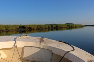
Morning trip to visit water quality monitoring sites near Sapelo Island, Georgia.
Credit: E Zambello/LTER-NCO CC BY 4.0
Every month, Field Technician Tim Montgomery loads his equipment onto a center console motorboat and heads off into the marshes surrounding Sapelo Island, Georgia. Over the course of several hours, he stops at multiple sites to check on the Georgia Coastal Ecosystem LTER network of data loggers continually collecting water quality parameters as they gently bob in the water. On one particular morning, I had the opportunity to go with him.
Five of us piled onto the boat with Tim—me plus four teachers participating in the hands-on LTER Schoolyard Program. In the gentle morning light, the shoreline glowed. The dominant grass species—Spartina alterniflora—undulated in soft waves as the coastal breeze pushed over the marsh, resembling a smaller ocean of green. Along the border of mud between the vegetation and water stood more herons, egrets, and other birds than I’ve ever seen in one place, including a rare wood stork or two. Tim took out a bird ID chart he kept on the boat; he uses his time on the water to learn about avian species.
Birds weren’t the only visible wildlife. Dolphin dorsal fins slipped in and out of the waves around us. One pod used their powerful tails to splash the edge of the channel, herding and startling fish so that their compatriots could feast. Calmer, but no less amazing, were the sea turtles popping their heads above the surface to give us a brief look-over before diving once more to deeper water.
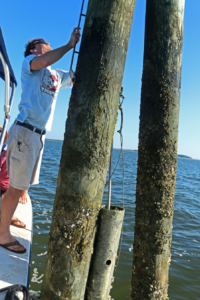
GCE Field Technician Tim Montgomery stabilizes the boat near a data logger.
Credit: E Zambello/LTER-NCO CC BY 4.0
Tending the instruments
Our first stop was at two wooden pilings near the middle of the channel. A wide PVC pipe contained the data logger, which Tim gingerly pulled up while balancing on the edge of the rocking boat. Covered with algae, crabs, and barnacles, this data logger—together with all the others surrounding Sapelo Island—is a critical component of GCE’s long term data collection on water quality. Every thirty minutes the loggers record water quality indicators including pH, salinity, dissolved oxygen, and temperature. Even in the middle of cleaning the instrument, Tim plopped it back into the water so the logger could take its measurements on time – every fifteen minutes.
Tracking the Watershed
The water quality data provides a critical record of changes within the watershed over time, and contributes to GCE’s current focus areas, which include tracking long-term changes in climate and human impact, describing ecological properties and how they change over time, and studying carbon cycling and storage. By looking at changes in water quality, sea level rise, and pulses of salt vs. freshwater compared to past records, scientists can assess the impact of long-term changes in climate and human actions in the watershed as well as temporal and spatial variability in physical, chemical, geological, and biological properties of the area.
While the data collection and maintenance of the equipment may be routine, the information these efforts provide is essential for the understanding of the Sapelo Island system as a whole. Local Georgia teachers experienced this data collection first hand on the boat that day, formulating their own questions about changing water systems in the nearby coastline. As they bring their experiences back to the classroom, the instructors also take with them data that stretches back decades, a numeric representation of the changing Georgia climate and landscape that they plan to incorporate into their science curriculum.
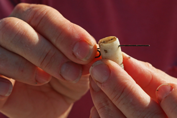
Cleaning equipment is essential in saltwater monitoring sites.
Credit: E Zambello/LTER-NCO CC BY 4.0


