Location
Site Details
Site Disposition:
BES LTER completed its last funding cycle from the National Science Foundation in November 2022. BES transitioned from an LTER site to a consortium to continue research after this date. This consortium is led by the USDA Forest Service, Cary Institute of Ecosystem Studies, and the University of Maryland Baltimore County among others. Responsibilities for continued BES research will be shared among these entities. Funding for continued work is being pursued in various forms from state, federal and private entities.Retrospective:
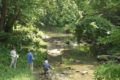
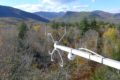
BES LTER was situated in the Baltimore Metropolitan Area. Watershed studies (which are ongoing through a Long Term Research in Environmental Biology (LTREB) grant beginning September 1, 2021) focus on the Gwynns Falls, which has headwaters in suburban Baltimore County, traverses older (1950s) suburban areas, enters Baltimore City where it flows through older residential areas and a large City park, and then drains into Baltimore Harbor. BES has four longitudinal long-term sampling stations on this stream:- Glyndon, in the headwaters;
- Gwynnbrook, approximately 25% downstream;
- Villa Nova, at the mid-point of the watershed; and
- Carroll Park, near the confluence with the harbor but above tidal reach.
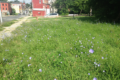
- Pond Branch, a forested reference site;
- Baisman Run, an exurban site with low-density residential development served by septic systems;
- McDonogh, an agricultural watershed; and
- Dead Run, an urban watershed.
Accomplishments:
The Baltimore Ecosystem Study (BES) began in 1998 with three questions to advance our understanding of urban areas as an ecosystem type. We posed three lines of investigation dealing with:- Structure: What is the spatial and temporal patch structure of ecological, physical, and socio-economic factors in the urban ecosystem?
- Function: What are the fluxes of energy, matter, and populations in the patches in the urban ecosystem? and
- People: What are the choices people and their organizations make that affect the urban ecosystem?
Research Areas:
Watershed research

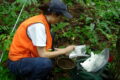
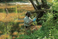
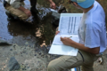
Watershed research is (ongoing with LTREB funding as of September 2021). Continuous data on stream stage and discharge are collected by the USGS. Stream samples are taken manually on a weekly basis and analyzed for nitrate, phosphate, total nitrogen, total phosphorus, chloride, sulfate, turbidity, temperature, dissolved oxygen, and pH. Select dates were run for cations, dissolved organic carbon and nitrogen, E. coli and contaminants such as metals and pharmaceuticals. From Jan 2017-August 2022, we measured dissolved oxygen and temperature every 5 min at the 8 stream stations to provide a new long-term record of stream metabolism, an indicator of whole stream ecosystem activity. All data are available (see below) and a subset of water samples are archived at the Cary Institute for Ecosystem Studies.
Biogeochemistry of terrestrial habitats

The BES established long-term study plots including 7 forest sites sampled since 1998 and 2 grass sites that have been sampled monthly since 2001. At these sites we measured soil temperature and moisture and make monthly measurements of soil:atmosphere fluxes of carbon dioxide, nitrous oxide and methane (in situ chambers), and leaching fluxes (zero tension and suction lysimeters) of N and P. Four riparian sites have been sampled for water table depth monthly since 2000 and gas fluxes monthly since 2012. The long-term study plots provided critical information for ongoing calculations of retention and loss of nutrients in the key ecosystem types of upland forest, residential, and riparian sites in the study watersheds. All data are available (see below). Monitoring of a subset of these sites is part of the LTREB project that began in September 2021.
Urban forest canopy

The main platform for long-term biotic data collection was the iTree sampling protocol that used standardized field data from 202 stratified randomly located plots to quantify urban forest structure, species composition, tree health, and diameter distribution (Nowak et al. 2008). iTree was used as a standardized data collection framework and not as a modeling tool in BES (cf. Pataki 2013). Sampling of woody plants was conducted 4 times (1999, 2004, 2009, 2014). At each plot, we identified and measured every individual woody plant to species and collected dimensional measures needed to estimate individual tree growth, health and mortality, net primary production, species composition, and changes in species composition (Nowak et al 2008; Swan et al. 2017). All data are available.
Sentinel Species

BES researcher included data collection on sentinel species in the urban landscape including birds, mosquitos, soil invertebrates, and riparian and upland herbaceous vegetation. These data are available (see below).
Human-Environment Interactions

The BES LTER studied multiple dimensions of human environment interactions. This research included a long-term telephone survey (conducted approximately every 5 years) investigating people’s environmental perceptions, investigation of the connections among environmental organizations, exploration of real estate transactions to explore the influence of environmental conditions on housing values, among others. The telephone survey is continuing as part of the LTREB project that began in September 2021.
Theoretical Advances in Urban Ecology

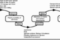
In addition to empirical studies and long-term measurements, the BES LTER made significant contributions to the theory of urban ecology. For more information on the theoretical advances that the BES contributed see Pickett et al. 2020 (see Figure 1). In addition to these conceptual advances from the project overall, BES research contributed to significant advances in studying urban landscapes, especially refining our understanding of the diversity of landcover in urban settings (see Pickett et al. 2019).
Advances in Urban Ecosystem Education

The BES LTER made significant contributions to the theory and practice of urban ecosystem education. Early work culminated in a Cary Conference that brought together scientists and educators from around the world and resulted in a synthesis volume (see Berkowitz et al. 2003). BES educators built on their long-term experiences to champion the incorporation of human/environment interactions into the Ecological Society of America’s Four Dimension Ecology Education (4DEE) Framework (see Klemow et al. 2019), and to integrate teaching and learning ecology in, of and for urban ecosystems in a number of innovative projects including the Pathways to Environmental Science Literacy, BioComplexity and the Habitable Planet and Integrating Chemistry and Earth Science.
Community Engagement and Education

Baltimore Ecosystem Study researchers have presented their work in conferences, classroom presentations, and other public events in the US and internationally, taught college courses that highlight BES research and data including a graduate urban ecology course at the University of the Chinese Academy of Sciences, Beijing, and were active members of professional organizations dedicated to various aspects of urban ecology, planning, and sustainability. Examples include the Baltimore County Commission on Environmental Quality (CEQ) and the EPA Chesapeake Bay Program Scientific and Technical Advisory Committee (STAC).
BES Annual Meetings have been held in October since 1998, usually with over 100 attendees. These meetings were free and open to the public. They typically included a keynote speaker, 1.5 days of ongoing and proposed BES research presentations from senior investigators, postdocs, and graduate and undergraduate students, a community Open House, and a graduate student seminar/workshop where student researchers had the opportunity to receive feedback on their work from senior investigators. In addition to the Annual Meeting events, three Quarterly Research Meetings were held each year. These meetings were also free and open to the public and typically had attendance of 30-40 people per meeting.
Our long-time community engagement partners, the Parks & People Foundation co-hosted the Annual Open Houses, which were held in a variety of locations including the Parks & People campus, the Eubie Blake National Jazz Institute and Cultural Center, and the American Visionary Art Museum. The Open Houses allowed BES to share key research and provide updates on its work to over 100 community members, city officials, local partners and other stakeholders each year.
Direct outreach to the local community included working with Baltimore City residents to evaluate strategies for mediating mosquito infestations and other community science endeavors. BES hosted field trips several times a year to promote the project and engage with a broader audience and included delegations from China, university and college urban ecology and planning classes, and site tours for our new researchers as part of their field safety training.
Communications activity included in-the-field press conferences that resulted in coverage by The Atlantic, CityLab, the Baltimore Fishbowl, the Baltimore Sun, the Chesapeake Bay Journal, among others. Our research has been covered by the Washington Post, NPR, and the New York Times, to name a few. The BES website was the primary public interface for the project and was most recently re-designed and re-launched in 2019. In 2017 we expanded our communications audience with the strategic use of the social media platforms Facebook, Twitter and Instagram, including the integration of the BES Twitter feed with the website. BES Twitter (@BESlter) will continue to be maintained after Nov 2021.
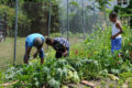
BES worked closely with teachers and education administrators in Baltimore City and County public schools since its inception in 1998 (see chapter 17 in Pickett et al. 2019). These efforts provided professional development and instructional resources to support teaching and learning in and about the local urban ecosystem while also addressing national, State and district standards. Strong partnerships were forged with both school systems over the 20+ years of BES work in the K-12 arena. One of the most significant outcomes of our partnership with Baltimore City Schools is the recent incorporation of BES data and urban ecosystem themes into the required curriculum for the high school chemistry course. Since 1998, we worked with over 250 teachers in the Baltimore region through a variety of education programs including the KidsGrow after school Ecology program, Research Experiences for Teachers and Teacher-in-Residence Fellowships, the Pathways to Environmental Science Literacy project, the Comp Hydro project, the Integrating Chemistry and Earth science project, and our periodic Environmental Science Literacy teacher workshops. BES also worked directly with youth through our Baltimore Data Jam Competition, involving hundreds of students over the past decade in exploring and creatively explaining local ecological data. In partnership with the Parks & People Foundation and their Branches Young Environmental Scientist internship program, BES worked with high school youth from groups traditionally underrepresented in STEM, engaging them in BES field protocols and raising their awareness of careers in ecology. Outcomes included 1) reaching thousands of students in the Baltimore City (ca. 80% African American, 10% Latino/a, and 9% white) and Baltimore County Public Schools (ca. 7% Asian, 39% African American, 10% Hispanic, 39% White, and 5% Two or More Races 5%), 2) research about teaching and student learning, and 3) curricular modules that integrate relevant urban ecological phenomena, emphasize schoolyard ecology, and highlight solutions to local environmental issues (Caplan et al. 20131 and Caplan et al. 20212) . See “Education” for Lead Researcher’s contact information and link to curricular materials.
BES has always engaged numerous participants. For example, during the decade from 2008 to 2018, BES had 92 investigators, 162 graduate students, 199 undergraduate students, 15 postdoctoral researchers, 6 education staff members, and 413 interested parties.
Data Stewardship and Sharing:
The BES data catalog consists of ~68 tabular datasets from field sampling and surveys, and ~99 spatial datasets (geographic information system [GIS] shapefiles). These data are all available from the EDI Data Repository, discoverable through DataONE search, and assigned a unique digital identifier (DOI).Data Package Updating and Maintenance
All tabular datasets have been imported into the EMLAssemblyline for R workflow (developed by the Environmental Data Initiative: EDI). In addition, BES-IM has developed a metadata template wrapper (a spreadsheet that is filled in by IM or data contributors), and an accompanying R script that extracts all elements from the spreadsheet and feeds information into the EML Assemblyline workflow. The EMLAssemblyline workflow was chosen because datasets are developed in a modular form, with all dataset components existing within an individual file folder (metadata templates, data entities, and EMLAssemblyline R script). With this workflow structure, the data package assets can be handed off to the original investigator, where they can easily update/modify data and templates, and build a new dataset revision with the included R script. By implementing EMLAssemblyline, BES successfully transitioned from a home-grown data package workflow, to one more widely used in the LTER community. Several core datasets are ongoing as part of the LTREB project that began in September 2021. To access BES data through the EDI portal, go to: https://portal.edirepository.org/nis/browseServlet?searchValue=BESContinuing Contacts:
Science
- Emma Rosi, Cary Institute of Ecosystem Studies, rosie@caryinstitute.org
- Peter Groffman, City University of New York and Cary Institute of Ecosystem Studies, groffmanp@caryinstitute.org
- Morgan Grove, US Forest Service, morgan.grove@usda.gov
Information Management
- Emma Rosi, Cary Institute of Ecosystem Studies, rosie@caryinstitute.org
- Mary Martin, University of New Hampshire, mary.martin@unh.edu
Education
- Alan Berkowitz, Cary Institute of Ecosystem Studies, berkowitza@caryinstitute.org
LTER Personnel
- Emma Rosi, Project Director from 2016-2021
- Steward Pickett, Project Director from 1998-2016, PI from 2016-2021<
- Peter Groffman, Deputy Director from 1998-2021
- Claire Welty, PI and Onsite Manager from 2000-2021
- Morgan Grove, PI and Lead of Social Science Research from 1998-2021
- Alan Berkowitz, Education Lead from 1998-2021
- Jonathan Walsh, Information Manager from 2000-2018
- Mary Martin, Information Manager from 2018-2021
- Holly Beyer, Project Coordinator 2005-2016
- Maribeth Rubenstein, Project Coordinator 2016-2021
Grant History:
LTER: Baltimore Ecosystem Study: Synthesis of long-term studies of how multiple human and biophysical factors interact to drive ecological change of an urban ecosystem
Start Date: December 1, 2018
LTER: Dynamic heterogeneity: Investigating causes and consequences of ecological change in the Baltimore urban ecosystem
Start Date: March 1, 2017
LTER: Baltimore Ecosystem Study Phase III: Adaptive Processes in the Baltimore Socio-Ecological System from the Sanitary to the Sustainable City
Start Date: February 1, 2011
LTER: Human Settlements as Ecosystems: Metropolitan Baltimore from 1797 – 2100: PHASE II
Start Date: March 15, 2005
Urban LTER: Human Settlements as Ecosystems: Metropolitan Baltimore from 1797 – 2100
Start Date: October 31, 1997